Research
Dr. Fengpeng Sun specializes in numerical modeling of the Earth's climate, its variability and change. The scope of his work includes development of high-resolution climate modeling framework, diagnostic analysis of physical climate processes in the climate system, understanding past climate and its variability, and projecting future climate change and its socioeconomic impacts from a regional/local perspective, which is most relevant to human activities. His research has been sponsored by government agencies such as NSF, NASA, NOAA, private sectors and University of Missouri etc.
Ongoing research:
Dr. Sun and his research group's current focus is investigating the regional climatic impacts of human-induced land use and land cover change. They are currently studying the urban heat island (UHI) effect in the Kansas City metropolitan area (KCMA) using both high-resolution (1km by 1km) regional Weather Research and Forecasting (WRF) model simulations, in-situ observations and field campaign measurements. The UHI effect is a phenomenon where temperatures within a city are warmer than those of surrounding rural and suburban areas, especially at nighttime. They have been able to compare the change in the UHI magnitude and areal extent in the KCMA using present-day and historical climate and land cover data sets. In addition, they have explored the potential roles of climate mitigation strategies, such as cool roofs, which reflect more sunlight and and absorb less heat than a standard and conventional roofs. Their research has shown that cool roofs are effective at reducing urban temperatures in the KCMA, especially during heat wave events.
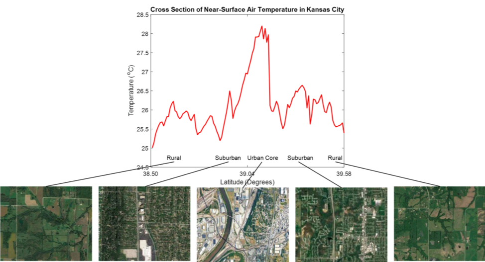 |
| Figure: Two-meter air temperature (T2) from a north-south cross-section through the Kansas City metropolitan area at approximately -94.6° longitude. Differences in two-meter air temperature are strongly influenced by land cover type, creating the urban heat island effect. |
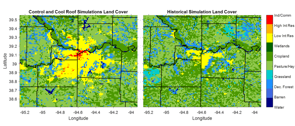 |
| Figure: High-resolution (1 km by 1 km) land cover of the innermost domain from the WRF simulations. Left: Present-day (2011) and Right: modeled historical (1938) KCMA land cover. |
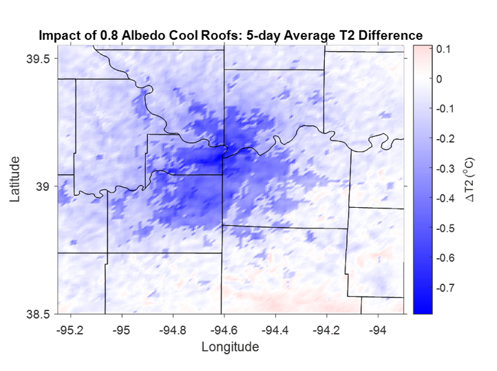 |
| Figure: Cooling impact of widespread deployment of cool roofs (with 0.8-albedo) on two-meter air temperature (°C) in the KCMA during a recent heat wave event. |
Recent research:
(I) Dr. Sun's recent research included developing dynamical and statistical downscaling techniques and applying them to projecting future climate change in California, with an emphasis on hydroclimate over the Sierra Nevada Mountains. In this project, he designed the high-resolution regional climate modeling experiments using Weather Research and Forecasting Model (WRF), performed multi-decadal simulations and projected the end-of-21st-century hydroclimate changes (e.g., snowpack, precipitation, runoff, soil moisture) and weather extreme changes at 3-km resolution over the Sierra Nevada and 9-km resolution over California.
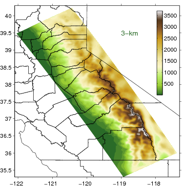 |
| Figure: WRF model resolved high-resolution (3km by 3km) topography from the dynamically downscaled simulations in the California Sierra Nevada Mountains. |
(II) His recent research also included reconstructing historical climate and projecting climate change in the Greater Los Angeles Area with dynamical downscaling using regional WRF model and statistical downscaling techniques. Using this hybrid dynamical and statistical framework, he downscaled dozens of currently available coarse-resolution global climate models to 2-km resolution and projected mid- and end-of-21st-century climate changes in temperature, precipitation, snowpack and surface runoff in the region under various greenhouse gas emissions scenarios. He also collaborated with ecology scientists and investigated how the interactions between regional climate change and local ecosystems change the wild fire regime in southern California mountains and subsequent socio-economic impacts.
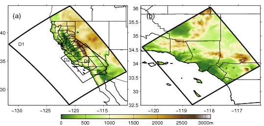 |
| Figure: (a) Model setup with three nested WRF domains (D1, D2, and D3) at resolutions of 18, 6, and 2 km; D1 Topography (m) is shown in color. (b) The innermost domain (D3) of the regional simulation, with 2-km resolution. |
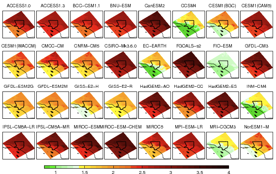 |
| Figure: Annual-mean warming patterns (°C) generated by applying the hybrid dynamical-statistical downscaling technique to all available 32 CMIP5 GCMs. Warming patterns are shown for the mid-21st-century period (2041–60) relative to the baseline period (1981–2000), under the RCP8.5 emissions scenario. |
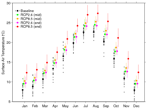 |
| Figure: Annual cycle of Los Angeles region surface air temperature (°C) for the baseline period (black), mid-21st-century under RCP2.6 (green), mid-21st-century under RCP8.5 (orange), end-of-21st-century under RCP2.6 (magenta), and end-of-21st-century under RCP8.5 (red). Black solid dots denote the 20-yr baseline climatology, and black open circles denote monthly mean for each year during baseline period (1981–2000). Other solid dots denote the ensemble-mean climatology for their respective scenario and time slice; bars denote the range across all the downscaled GCMs. |
Ph.D. research:
In his Ph.D. research, he examined tropical Pacific climate dynamics and ocean-atmosphere interactions with a focus on El Niño-Southern Oscillation (ENSO) and its decadal modulation using multiple observational, satellite and reanalysis data as well as atmospheric modeling with Community Atmospheric Model (CAM). He also investigated the ENSO simulation bias in global climate models, such as Community Climate System Model version 3 (CCSM3) by designing and analyzing ocean-atmosphere coupled and decoupled sensitivity experiments and proposed a theory to explain the ENSO bias and its linkage to the Indian Ocean and monsoon variability.
Prior to his Ph.D. work, he focused on the roles of weather extremes, e.g., strong mountain-gap wind in regulating sea surface temperatures by designing and implementing Regional Ocean Modeling System (ROMS) experiments.